Map size in jpg-format: 25.2417MiB
Click to open in high resolution (open in new tab).
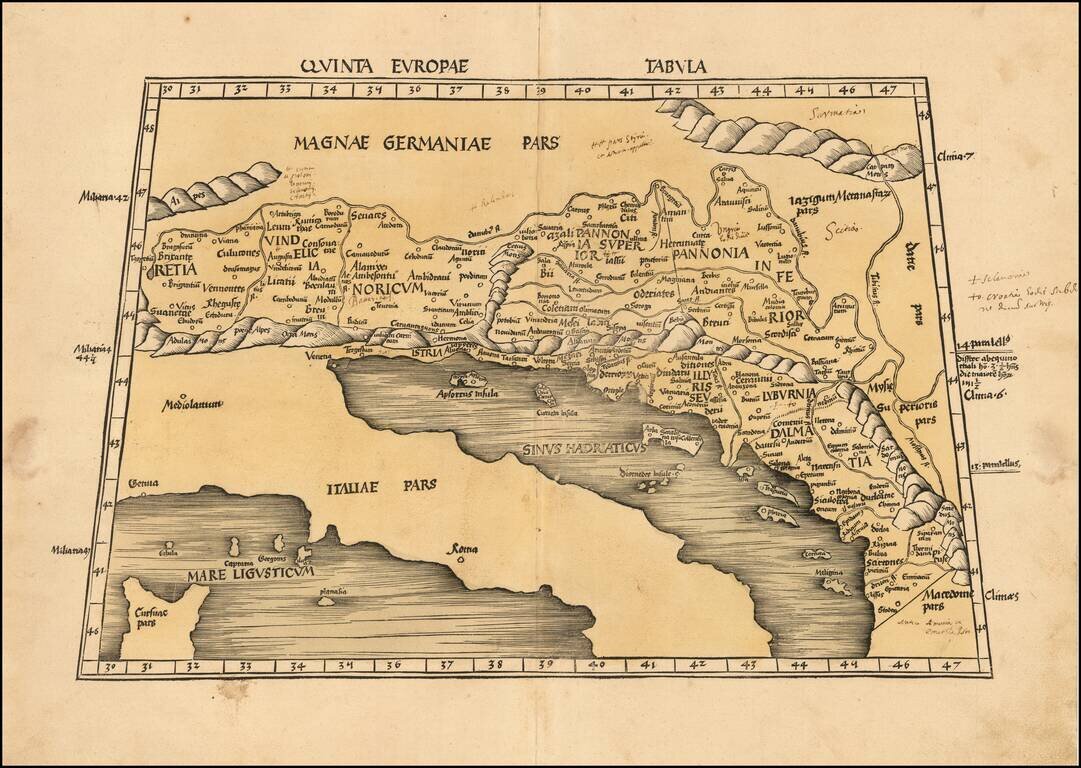
Nice example of Martin Waldseemuller's map of the region between the Danube River and the Adriatic Sea from the 1513 edition of Waldseemuller's Geographia.
The map extends from Italy and the Adriatic Sea in the South to Austria, Croatia, Slovenia, Switzerland and regions south of the Danube.
The map extends from Riga, Moscow and the Baltic Sea in the north to Venice, Bosnia and Istanbul in the south, centered on Poland and Hungary.
Martin Waldseemüller, a highly accomplished scholar of geography, merged the science of mapmaking and the art of printing in his 1513 atlas, one of the most groundbreaking documents in the history of cartography. He intended this atlas as a new edition of Ptolemy's Geographia, but included the addition of 20 modern maps which were not based upon the tradition of Ptolemy. Waldseemuller's use of a quadratic plane projection, was also a noteworthy advance.
Martin Waldseemüller (1470-1520) was born in Wolfenweiler and studied at the University of Freiburg. On April 25, 1507, as a member of the Gymnasium Vosagense at Saint Diey in the duchy of Lorraine, he produced a globular world map and a large 12-panel world wall map ( Universalis Cosmographia) both bearing the first use of the name "America". The globular and wall maps were accompanied by a book Cosmographiae Introductio, an introduction to cosmography. The book, first printed in the city of Saint-Dié-des-Vosges, includes in its second part, a translation to Latin of the Quattuor Americi Vespuccij navigationes (Four Voyages of Americo Vespucci), which is apparently a letter written by Amerigo Vespucci, although some historians consider it to have been a forgery written by its supposed recipient in Italy. In chapter nine of the first part of the Cosmographiae Introductio, written by Mat(t)hias Ringmann, it is explained why the name America was proposed for the then New World.
In 1513 Waldseemüller appears to have had second thoughts about the name, probably due to contemporary protests about Vespucci's role in the discovery and naming of America, or just carefully waiting for the official discovery of the whole northwestern coast of what is now called North America, as separated from East Asia. In his Geographia, the continent is labelled simply Terra Incognita (unknown land). Despite the revision, 1,000 copies of the world maps had since been distributed, and the original suggestion took hold. While North America was still called Indies in documents for some time, it was eventually called America as well.
If you are a student, write to us in telegram: @antiquemaps and indicate what material you need and for what work you need a map in high detail. We are ready to provide material on special terms. For students only!