Map size in jpg-format: 27.486MiB
Click to open in high resolution (open in new tab).
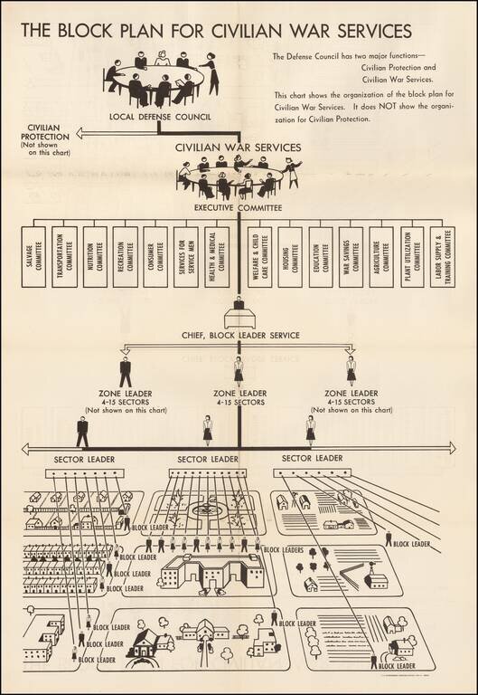
World War II Civilian War Services Organizational Chart
Unusual organizational chart showing the means for organizing civilians during World War II.
As the chart notes, this is the Civilian War Services chart, NOT the chart for Civilian Protection. The following is excepted from the Oregon Secretary of State's website:
The U.S. Office of Civilian Defense (OCD) organized and promoted the block plan to states in 1942 to be patterned after the familiar air raid block warden plan. It was suggested, for the sake of simplicity, the war services plan be overlaid on the existing geographical boundaries of the air raid plan. The government asked cities with a population of 2,500 or more to set up the block plan. The federal Agriculture Extension Service helped develop a similar system for rural areas that included neighborhood leaders. As part of the plan, a typical city hierarchy was devised to reach every home. At the top was the chief of the city's block leader service, followed by zone leaders who had jurisdiction over 4 to 15 sector leaders. These volunteers in turn would manage the efforts of a number of block leaders. Each block leader had responsibility for about 15 families. Because of varying housing facilities, a typical neighborhood block with single family detached homes might have one block leader while a more high density block with large apartment buildings might have three block leaders. While the program saw variations to meet local circumstances, officials wanted to avoid overloading block leaders with too many households.
Block leaders filled a role similar to that of the air raid block wardens, only in relation to war services instead of civilian protection. According to the Portland and Multnomah County Civilian Defense Council, block leaders functioned to develop a cooperative unit through "block discussion meetings, rallies, car sharing plans...and any other activity of the committee's war services." Specifically, they were to explain how households could participate in community programs such as salvage and Victory Gardens; gather survey data needed to develop war services efforts such as those related to child care and housing; promote participation in war programs such as blood donations and immunizations; and assist the local volunteer office in recruiting volunteers for defense council programs and recruiting for paid positions in critical jobs in war industries, professional nursing, and women's branches of the armed services. Block leaders were "supposed to have the confidence and goodwill of the people in your block; you are the morale builder; an information bureau; a solicitor; a salvage worker and many other things rolled into one."
The chart is rare. We locate only one example, in the North Carolina State Library Collection.
If you are a student, write to us in telegram: @antiquemaps and indicate what material you need and for what work you need a map in high detail. We are ready to provide material on special terms. For students only!
![[Signed Political Satire Artwork] Vietnam ... Vietnam ... Vietnam ...](/map/small/68726.jpg)